Kamejima River is a relatively short river of about 1.1 km in length that flows through the two corners of Reigishima Island, commonly known as Shinkawa in Chuo-ku, Tokyo.
This Kamejima River flows into the Sumida River, and the bridges over the Kamejima River are
There are five bridges over Kamejima-gawa: Reigan-bashi,Shin-kamejima-bashi,Kamejima-bashi,Takahashi, andMinamitakahashi.
This area used to be the sea, but the Reigishima area was a populated island created by reclaiming the sea with soil left over from cutting down Mount Kanda (present day Surugadai) and building a moat (canal) during the Tokugawa Ieyasu era. This reclamation is still in process today, and it can be said that the reclamation made the Tokugawa Shogunate and Edo prosperous, which is the reason why Tokyo is where it is today.
This area is now the waterfront and a key part of the metropolis of Tokyo, but it was also a key location for the Tokugawa Shogunate in the Edo period.
There are many monuments and relics that remind us of the Tokugawa Shogunate, such as Matsuo Basho, Sharaku, Echizen-dori and Tokufune Inari Shrine.
This site, “Tokyo Kamejima River Riverside Guide”, will introduce you to the bridges over the Kamejima River, nearby sites, monuments and scenery, and will also provide you with episodes and trivia about Edo culture and the Tokugawa Shogunate.
Yeongamdo Monument
There is a monument of Reigando Island in Echizenbori Children’s Parknear the second Shin-Kameshima Bridge ofKameshima River.
Yeongam Island Monument and Explanatory Notes 
A part of the present Shinkawa River used to be called Reigishima, which was built by Priest Reigan Yuho in 1624 by reclaiming a sandbar in the Sumida River, and was called Nakanoshima or Konnyakujima. The reason why it was called Konnyaku-jima is because this area was reclaimed land and the ground was soft and “squishy” in the early days.
Yeongam Island Monument 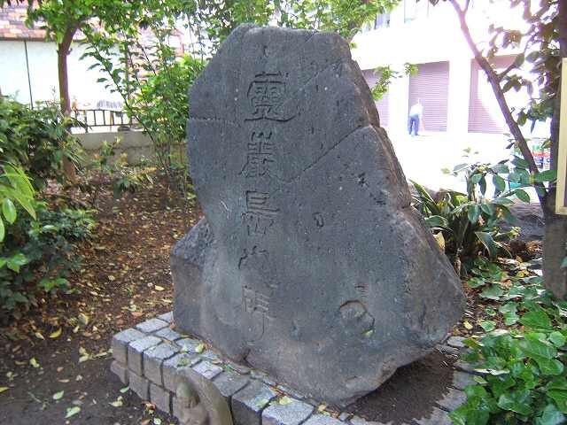
Yeongam Island Description 
This area was a swampy reed bed when the castle town of Edo
When the castle town of Edo was developed, this area was a swampy reed bed.
In 1624, Priest Yuho Reigan built Reiganji Temple and took the first step in land development.
The first step of land development was taken in 1625 when Priest Yuho Reigan built Reiganji Temple.
In 1635, Matsudaira Tadamasa, the feudal lord of Echizen Fukui, built the Hama Yashiki (beach residence) in the southern part of the temple grounds, covering an area of more than 27,000 tsubo.
In 1635, Matsudaira Tadamasa, the feudal lord of Echizen Fukui, received the Hama Yashiki, a residence covering an area of more than 27,000 tsubo (about 1,860 square meters).
Funairibori moats were dug on the north, west and south sides of the mansion, which later gave rise to the name of Echizenbori.
This was the cause of the name “Echizenbori” later.
In the great fire of 1657, Reiganji Temple was burnt down and moved to Fukagawa Shirakawa-cho.
The site was used as official land, and towns and cities in the city
The site was used for official use, and towns and cities in the city moved there collectively as replacement land.
In the Meiji Taisho era, Tomishima-cho, Hama-cho, Yokkaichi-cho, Shiomachi, Okawabata-cho, Kawaro-cho, Nagasaki-cho
town, Kawaro-cho, Nagasaki-machi, Reigishima-machi, Gin-machi, Higashiminatomachi, Shinfunamatsu-machi, Echizenbori, and Minami-shinbori.
There were many people who paid a lot of taxes and there was a tidal observation station.
There was a tide observation station, and it was the center of downtown commerce as the arrival and departure point of marine transport in the bay and a warehouse area.
It was the center of downtown commerce as a bay shipping depot and warehouse district. The entire area was scorched by the Taisho Earthquake.
The whole area was scorched by the Taisho Earthquake, and in July 1931, the name of the town was changed to Shinkawa 1, 2, and 3.
The town was renamed Shinkawa 1, 2-chome, Reigishima 1, 2-chome, Echizenobori 1, 2, 3-chome.
In 1971, the name of the town was changed to Shinkawa 1, 2-chome, Reigishima 1, 2-chome, and Echizenbori 1, 2, 3-chome, and furthermore
The name was changed to Shinkawa 1, 2-chome, Reigishima 1, 2-chome, Echizenbori 1, 2, 3-chome in 1971. The nostalgic ruins that symbolize the history of the area since the Edo Period have also disappeared.
This monument is erected to commemorate the disappearance of nostalgic ruins that symbolize the history of the area since the Edo Period, and to show our concern for their disappearance.
I am erecting this monument to commemorate the disappearance of these nostalgic remains that symbolize the history of the area since the Edo Period.
March 1977 Reigando Preservation Society
Echizen-dori Children’s Park
Walking from Shinkameshima Bridge in the direction of Sumida River for about 3 to 5 minutes, you will find Echizenhori Children’s Park.
There is no shortage of things to talk about in this park, such as the Yeonggamdo Monument, the Echizen-dori Stone, and the Jabujabu Pond.
Monument of Echizen-dori Children’s Park 
This area was the residence of Matsudaira Echizen-no-Mamoru, the lord of Echizen Fukui, and it was called “Echizen-dori” because three sides of the residence were surrounded by a moat.
Even today, stone wall stones that seem to be Echizen-dori are sometimes unearthed during construction work or investigation of ruins.
In the Meiji era (1868-1912), the mansion of the Echizen no Mamoru was renamed “Echizen-dori”, but the moat was gradually reclaimed.
After the Great Kanto Earthquake in 1923, most of the land was reclaimed, and the part used for the Sumida River, which remained only a little, was completely reclaimed after the war.
After that, the name of the town became Shinkawa, and it has come to the present.
Currently, the name “Echizen-dori” can only be found in this Echizen-dori Children’s Park.
Explanation of the origin of the stone 
Origin of the stone
The stone used in this park was created in 1985
when the Tokyo Metropolitan Government carried out repair work on the right bank of the Nihonbashi River
The stone is a part of the stone wall that was generated near the Kiji Bridge.
The Tokugawa Shogunate constructed the second phase of Edo Castle in 1605.
The Tokugawa Shogunate built the second phase of Edo Castle in 1605.
The Tokugawa Shogunate ordered the transportation of the stone walls of Edo Castle and moat to the 31 feudal lords of Chugoku, Shikoku, and Kyushu.
The Tokugawa Shogunate ordered the 31 feudal lords of Chugoku, Shikoku, and Kyushu to collect and transport the stones for Edo Castle and moat. Most of the stones
Most of the stones were quarried from the east coast of the Izu Peninsula and transported to Edo
The majority of the stones were quarried from the east coast of the Izu Peninsula and transported to Edo, but there were a series of
The work of cutting out the stones, transporting them to the coast, and unloading them was extremely difficult and cost a great deal of money.
extremely difficult, and a great deal of money, labor, and
The stone was cut out of stone, transported to the coast, and landed at Koto.
The stones are also marked with emblems and markers that are thought to belong to the lords
Some of the stones are engraved with crests and landmarks that are thought to belong to the
and markers on some of the stones.
Park Division, Public Works Department, Chuo City
Echizen Boat in Jabu-Jabu Pond in Echizen-dori Park 1 
In this park, there is a pond called “Toshoike” where an objet d’art of Echizen-bune (Echizen Boat) is made with an elephant for some reason. Wading means “walking across a river”, and this pond is also called “Jabujabu-ike”. It is a great park for children.
Echizen-bune in Jabu-Jabu Pond in Echizen-dori Park 2 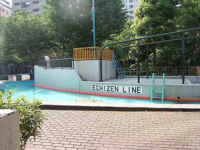
Echizen-bune in Jabu-Jabu Pond in Echizen-dori Park 3 
Scenery of Echizen-dori Park 1 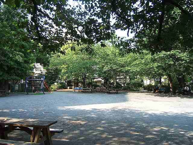
Scenery of Echizen-dori Park 2 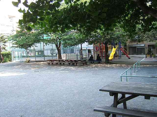
Excavated stone wall stones 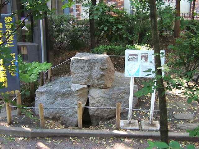
Description of the excavated stone wall stones 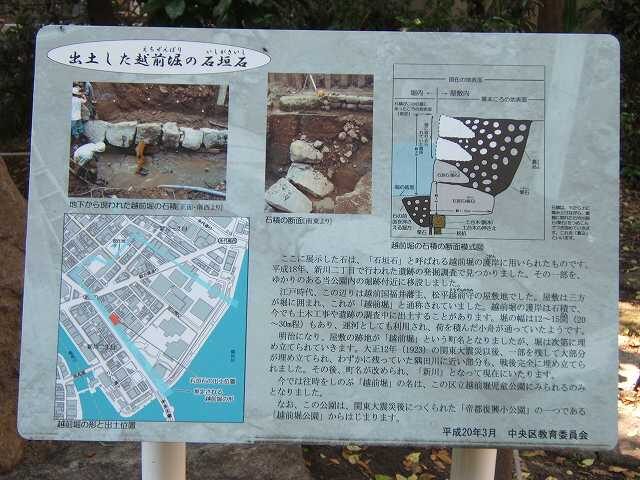
Monument to Takeyoshi Horibe Yasube
Near Kamejima Bridge, the third bridge of Kamejima River, there is a monument of Horibe Yasube Takeyoshi.
Yasubei was born in Niigata-Shinbata, became a ronin and went to Edo, and lived in Shindo-cho, Shinjuku-ku today, but he also lived here.
Monument of Horibe Yasube Takeyoshi near Kamejima Bridge1 
Horibe Yasube Buyo, who played an active role in Ako Ronin and Chushingura, lived in Mizutani-cho (present Hacchobori 1-chome) at that time, called himself Akasaya Yasube and was known as a master of kendo, and his bravery was transmitted throughout Edo during the famous Takadanobaba revenge attack in the 7th year of Genroku.
Horibe Yasube Takeyoshi is read as “Horibe Yasube Takenone”. His father was Yajiemon Nakayama and his family name was Nakayama, but when Yahei Horibe, a vassal of the Hotoasano family, learned about the Takadanobaba revenge incident, he wanted to adopt him and changed his family name to Horibe.
Akasaya is read as “Akazaya”. Why was it called Akasaya Yasubei? That is under investigation(^). Please let me know if you know. Click here for contact information.
Monument of Horibe Yasube Takeyoshi near Kamejima Bridge 2 
This monument to Takeyoshi Horibe Abe was made by the Hachimachibori Ichimachi Town Council in August 1969.
Monument of Horibe Yasube Takeyoshi near Kamejima Bridge 3 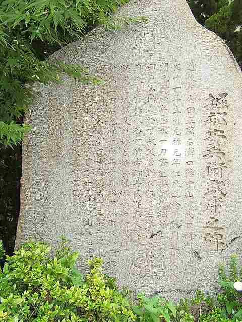
I transcribed the inscription. Sorry if it is wrong(^^)
Horibe Yasube Takeyoshi Monument
Son of Yajiemon Nakayama of the Echigo Shinbashida Gomangoku Mizoguchi Domain
Born in the 11th year of the Kanbun Era and entered the Edo Nenenki Horiuchi Dojo in the 1st year of the Genroku Era
Tamaki Ittosai Dojo Shihan in the 4th year of Genroku in February of the 7th year of Genroku in Takada no Baba
Avenged his uncle Rokuroemon Sugano
After that, he continued to live with the family of Jirotayu Hosoi, a Confucian scholar in Kyobashi Mizutani-cho.
He married a vassal of the Asano family, Horibe no Myo, and became Horibe Yasube Takeyoshi.
In October 14 of the 14th year of the Genroku era, he became a kendo instructor under the name of Nagae Saemon in Hayashi-cho, Honjo.
On December 14, 15 Genroku, as one of the Ako Yoshi, he entered Kira’s house and avenged the death of Kira.
He died on February 4, 16th year of Genroku at the age of 34.
Dharma name: Katagumo Kiken Shinji
Matsuo Basho Haiku Monument
There is a Matsuo Basho haiku monument near Kamejima Bridge, the third bridge on the Kamejima River.
Matsuo Basho haiku monument near Kamejima Bridge 
Matsuo Basho, famous for the Narrow Road to the Deep North, was born around Iga City in Mie Prefecture, but it seems that he once lived by the Sumida River. He also traveled all over the world, so I think there are many monuments of this kind, and there was one on Kamejima Bridge (laugh).
There is a theory that Matsuo Basho was a ninja or a secret agent. This is due to the fact that he was born in Iga-Ueno and his life was full of travel, but we don’t know how true this is.
Enlargement of Matsuo Basho’s haiku monument near Kamejima Bridge 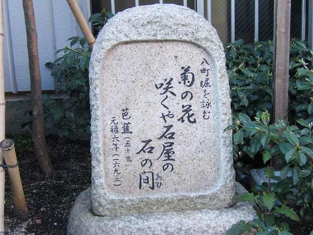
Poem of Hachimachi digging
Chrysanthemum flowers
Blooming or in a stone house
between the stones
Basho (age 50)
The 6th year of the Genroku era (1693)
In this monument, it is inscribed “Hatcho-Hori” instead of “Hatcho-Hori”. I guess it could have been either.
In the old days, in the Edo period, there were many stone masons in this area. Come to think of it, there is an Ishikiri Bridge on the Kanda River.
It must have been convenient to transport them because the moat is so close.
Now, this haiku, “Chrysanthemum flowers bloom or between stones in a stone house” has a dainty feel to it. It is quintessential Basho sensei.
Sharaku and Ino Tadataka
Near Kamejima Bridge, the third bridge of Kamejima River, there are guide plates of Toshusai Sharaku and Ino Tadataka besides the remains of Horibe Yasubei’s residence.
With materials like this, I am deeply moved by the fact that Edo culture was transmitted from this area.
Sharaku and Ino Tadataka Guide Edition 
Enlargement of Sharaku 
Toshusai Sharaku
Ukiyoe artist of the Edo period. He was born in the period from Tenmei to Kansei
He was born around 1794.
He painted yakusha-e (portrayals of actors), yakusha-e (portraits of actors)
He produced about 140 prints of yakusha-e (portrayals of actors) and sumo pictures in ten months from May 1794 to New Year’s Day of the following year.
Sharaku produced about 140 prints of yakusha-e (portrayals of actors) and sumo pictures in ten months from May 1794 to New Year’s Day of 1995.
Sharaku produced about 140 prints of yakusha-e (actor pictures) and sumo pictures
Sharaku painted gorgeous backgrounds and realistic expressions and
realistic expressions and figures, and is known around the world as one of Japan’s leading ukiyoe artists.
Sharaku is known throughout the world as one of Japan’s leading Ukiyo-e artists.
Sharaku’s life and identity have remained largely unknown.
However, Gesshin Saito, an archaeologist at the end of the Edo period, wrote a book entitled “Zensho Ukiyo-e Ruikou (
In 1841, Gesshin Saito, an investigator of the end of the Edo period, wrote, “Sharaku was an ukiyoe artist who lived in Hatchobori, Edo.
Sharaku was a Noh actor of the Awa clan who lived in Hatchobori, Edo.
The name “Sharaku” was written as “Saito Jurobei, a Noh actor of the Awa clan who lived in Edo Hatchobori.
In addition, in 1997 (Heisei 9), a Sharaku
In addition, in 1997 (Heisei 9), a past book in Hokoji Temple in Koshigaya City, Saitama Prefecture, states that “Jirobei Saito
Jirobe Saito, who lived in Jizobashi, Hatchobori, Edo, and served the Awa clan.
Jurobei Saito, who lived in Jizo-bashi, Hacchobori, Edo and served the Awa clan, was buried in the temple on March 7, 1820 at the age of fifty-eight.
He died on March 7, 1820, at the age of fifty-eight.
Sharaku and Jurobei Saito were the same person, and that he died at the age of 58 on March 7, 1820.
Sharaku and Jurobei Saito were the same person and lived here in Hacchobori.
Sharaku and Jurobei Saito were the same person and lived here in Hacchobori.
Sharaku and Jurobei Saito were the same person and lived here in Hacchobori.
Expansion of Ino Tadataka 
Ino Tadataka 1745 – 1818.
He laid the foundation for the modern cartography of Japan. He was a feudal lord of Shimousa Province (Sawara City, Chiba Prefecture).
He was a feudal lord in Shimousa Province (Sawara City, Chiba Prefecture), but at the age of 52, he left for Edo and began to study Western astronomy.
He studied Western astronomy in Edo (now Tokyo) at the age of 52. From the age of 56 to 72, he spent a total of
surveyed the whole country of Japan on foot for a total of 3,737 days, covering a distance of about 40,000 kilometers.
He surveyed the whole country of Japan on foot for a total of 3,737 days, covering about 40,000 km. He compiled the results of his survey in a book titled
The results were compiled in the book “Nihon no Kaigai Koshi Chi Zenkoku, Jisso Roku” (All Japan Coastal
The results of his work, “Nihon maritime yoso Zenkoku, Jisatsuroku” (The Complete Survey of Japan)
contributed greatly to the eight points of Japan, and was
and was highly evaluated overseas as well.
In 1814, he left his residence in Fukagawa
Tadataka moved his Fukagawa residence to Hacchobori Kamejima-cho
Tadataka moved his residence in Fukagawa to Kamejima-cho, Hacchobori.
continued to make maps and died there four years later.
died four years later in this place.
Tokufune Inari Shrine
The Tokufune Inari Shrine is located near the south bridge of the Kamejima River.
The steel frame in the back of the photo is the Minami-takabashi bridge, only a short distance from the Sumida River.
Tokufune Inari Shrine is closely related to the Tokugawa family, as you can see in the “Description of Tokufune Inari Shrine” below.
Tokufune Inari Shrine 
Description of Tokufune Inari Shrine 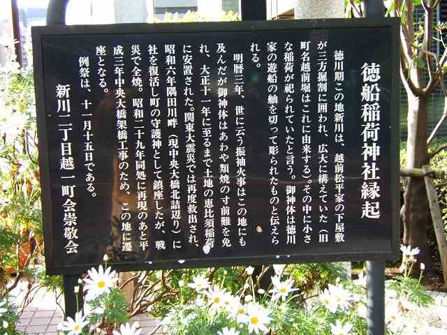
History of Tokufune Inari Shrine
During the Tokugawa period, the Echizen Matsudaira family had a grand residence on the Shinkawa River, surrounded by ditches on three sides.
The old name of the town, Echizen-no-Hori, is derived from this.
The old name of the town, Echizen-dori, is derived from this). A small Inari shrine was enshrined in this area.
The shrine is said to have enshrined a small Inari shrine in the middle of it. The sacred body is a bow of a pleasure boat of the Tokugawa family.
The sacred body is said to have been carved from a bow of a pleasure boat of the Tokugawa family.
The shrine is said to have been carved on the bow of a ship of the Tokugawa family.
In the third year of Meireki Era, the Furisode Fire
The sacred object was saved from being burned down in the fire, and it has been preserved until 1922.
The sacred body of the goddess was enshrined in Ebisu Inari
The sacred body was rescued again after the Great Kanto Earthquake. It was rescued again after the Great Kanto Earthquake.
In 1931, the shrine was restored on the bank of the Sumida River (now the north end of the Chuo Ohashi Bridge) and became the guardian deity of the shrine.
shrine was restored and it was enshrined as a guardian deity, but it was burnt down
However, it was burnt down in the war. In 1944, the shrine was rebuilt at the same place.
The shrine was relocated to this place in 1928 due to the construction of the Chuo Bridge.
The shrine was relocated to this site in 1928 due to the construction of the Chuo Ohashi Bridge.
The annual festival is held on November 15.
Shinkawa 2-chome Koshiichi Town Association
Teppozu Inari Shrine
Teppozu Inari Shrine is located on the right side of Teppozu Street, the first intersection after crossing Minami Takahashi, which is also “Sakura Street”, with Tokufune Inari Shrine behind you, and turning left.
The address is 1-6-7 Minato, Chuo-ku.
Front of Teppozu Inari Shrine 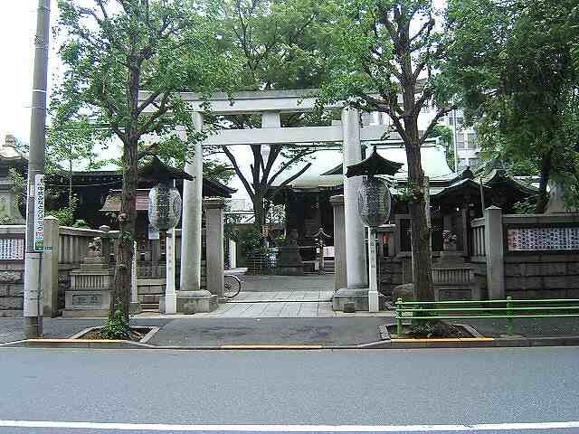
The name “Teppozu” is said to come from the topography of this area, which is a sandbank, shaped like a gun (a large cylinder).
Also, there used to be a moat called Teppozu River, but it was filled up around the time of the Great Kanto Earthquake and is not there now.
Right hand side of Teppozu Inari Shrine 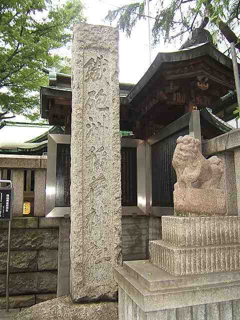
Explanatory plate of Teppozu Inari Shrine 
Teppozu Inari Shrine
Teppozu Inari Shrine is located at the entrance of the Edo
The shrine was built around 1624 to the southeast of the Inari Bridge.
The shrine was moved to the southeast corner of Inari Bridge around 1624.
In the first year of Meiji (1868), the shrine was relocated to the present location, where it remains to this day.
The shrine was relocated to the southeast of Inari-bashi Bridge in 1624. The precincts of the shrine were damaged by the Great Kanto Earthquake
(The shrine is located in the center of the front.
The shrine pavilion is in the center of the front, the Kaguraden and the regent Hachimangu shrine are on the left, the shrine office is on the right, and the hand-watering basin is facing each other.
The shrine office and the hand-watering basin are placed facing each other on the right hand side.
Fuji, which was built with lava from Mt.
Fuji, and it was used as a place of worship. Fuji, and it was used as a place of Fuji worship.
Fuji, and it was a place of Fuji worship.
The precincts of the shrine show well the architecture and layout of the shrine in the early Showa period.
Fuji mound is the only one in the district that still retains
Fuji mound is the only one of its kind in Chuo City, and it is registered as a Chuo City
Fuji mound is also registered as a Chuo City Cultural Asset.
March 1993
Chuo City Board of Education
Foreground view of the hand-watering basin at Teppozu Inari Shrine 
Tezumisha Konnichiwa 
reflection
When you are overpowered
God will abandon you
When we are greedy
When we are deceived by money
When you refuse
You will have no friends
When you are angry
You lose yourself.
-Masamitsu…
鉄砲洲稲荷神社の社殿 
Hyakudoishi at Teppozu Inari Shrine 
Tub at Teppozu Sengen Shrine 
Chikishi at Teppozu Sengen Shrine 
Teppozu Sengen Shrine
The Teppozu Sengen Shrine is located in the TeppozuSengen Shrine.
Teppozu Sengen Shrine Directions Edition 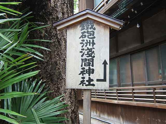
Fuji, and are often enshrined at the top of a mountain called Fuji-zuka, which is built in the shape of Mt. The Fuji mound at Teppozu Sengen Shrine was built with lava from Mt.
Torii of Teppozu Sengen Shrine 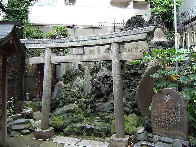
Fuji worship meant that climbing Mt. Fuji was a painful thing, and it was considered training to endure and overcome such pain, but Mt. Fuji is far from Edo. Fuji, but Mt. Fuji is far away from Edo, so Fuji-zuka was created to make it easier for people to do Mt. Is it the stylishness and rationality of Edo people?
Explanatory monument at Teppozu Sengen Shrine 
Fuji no no no
The high heart of Fuji
If you keep it up all the time
To the dust at the foot of the mountain
should not be blotted out.
July 17, 1957
Teppozu Fuji Kou
Looking up at Teppozu Sengen Shrine 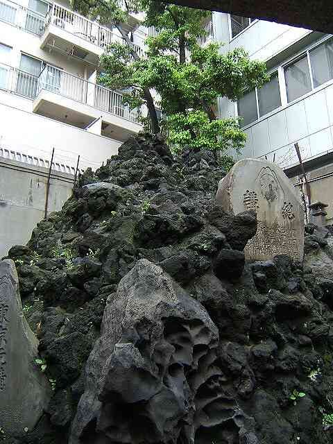
If you climb here, you will get the same benefit as climbing Mt.
Then, I’m going to challenge Mt.
Explanatory monument of Teppozu Sengen Shrine 2 
Fuji and the gods who live there, and is also called Sengen-ko.
Explanatory monument of Teppozu Sengen Shrine 3 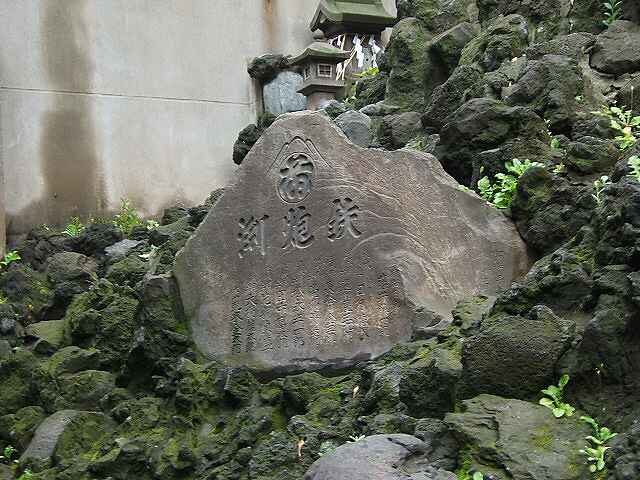
You don’t need caravan shoes to climb the mountain, but it is dangerous to wear sandals. Please wear solid sneakers and climb slowly. Fuji training, so don’t underestimate it.
Shrine of Teppozu Sengen Shrine1 
A shrine around the fifth station. The summit is near! Hang in there!
There are money-offerings. Don’t take it with you.
Shrine of Teppozu Sengen Shrine 2 
This is the shrine at the top of the mountain. Success in climbing!
The exhaust port in the back is from the building next door and has nothing to do with Teppozu Sengen Shrine.
Sumida River
The Kamejima River finally empties into the Sumida River.
This is the confluence of Kamejima River and Sumida River. If you go up the Kamejima River, you can reach the Nihonbashi River, Kanda River, Inokashira Pond and the source of the Kanda River in about 25 km!
If you go up the Sumida River, it becomes the Arakawa River at the Shin-Iwabuchi sluice gate, and if you go further up the river, you can get to the source (there are two theories…), but it is about 180 km, so if you go there, please be careful.
If you go down the Sumida River, you will reach Tokyo Bay in a few kilometers. You can go to Tokyo Bay!
Sumida River Scenery 1 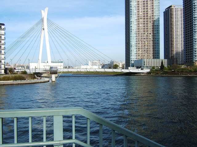
Crossing the Minami-takahashi, the last bridge on the Kamejima River, you will see the beautiful looking “Chuo Ohashi Bridge” when you go out to the Sumida River and look upstream of the Sumida River.
This Chuo Ohashi Bridge was completed on August 26, 1993, the same day as the Rainbow Bridge.
The white columns are X-shaped, and the upper part of the columns is designed as a helmet, but you may not be aware of the helmet unless it is explained.
Sumida River Scenery 2 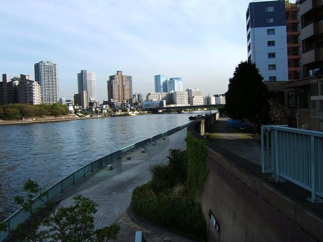
If you look downstream, you can see the Tsukuda Bridge.
The Tsukuda Bridge was built with the Tokyo Olympics in mind. The Tsukuda River that separated Tsukuda Island and Tsukishima at the time was reclaimed to make way for the Tsukuda Bridge, and the island that used to be Tsukuda Island became an island.
Sumida River Scenery 3 
Looking across the river, you can see the tall buildings of Okawabata River City 21.
Okawabata River City 21 is a group of 8 skyscrapers consisting of Century Park Tower, East Towers II, Skylight Tower, River Point Tower, East Towers, City Front Tower, Kosha Tower Tsukuda, and Shinkawa (Shinkawa is not on the opposite bank but on the Shinkawa side…)