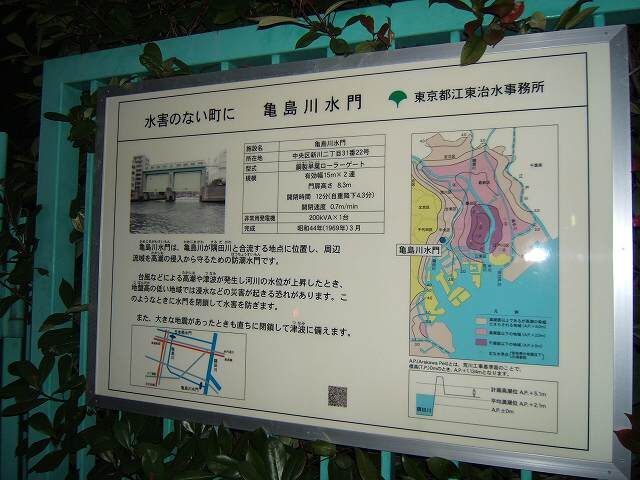
There are sluice gates at the entrance and exit of Kamejima River. The sluice gate between Nihonbashi River and Kamejima River is Nihonbashi Sluice Gate and the sluice gate between Kamejima River and Sumida River is Kamejima River Sluice Gate, which is to block water flowing back into Kamejima River during high tide and prevent flooding of Kamejima River.
Sakuragawa Canal and Shinkawa Canal used to be connected to Kamejima River since the Edo period, but both Sakuragawa Canal and Shinkawa Canal have been filled in and do not exist now.

Map around Kamejima River
Reigishima in Shinkawa, Chuo-ku, Tokyo is surrounded by three rivers: Nihonbashi, Kamejima River and Sumida River.
The Sumida River in this area is also called the waterfront, and it is close to Tokyo Station. Many major Japanese companies are located here, including the leading companies in the Tokyo Sumitomo Twin Building and the headquarters of Kirin Brewery.
There are many cherry trees along the Sumida River, and it is very beautiful when the cherry trees are in bloom.
Also, this area is often used for filming for TV and movies, and I have witnessed it several times. (I’m proud of it.)
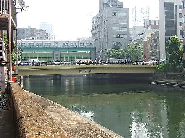
Nihonbashi Water Gate photographed from Reigan Bridge
This Nihonbashi sluice gate is usually open, but it closes during high tide to prevent flooding.
There is a traffic light, probably for boats.
Beyond this door is the Nihonbashi River. If you go up the river to the left beyond the door, this Nihonbashi River joins the Kanda River, and if you go down the river to the right beyond the door, this Nihonbashi River joins the Sumida River. If you go down the river in front of the door, it is Sumida River.
Nihonbashi Aqueduct photographed from Nihonbashi

The Nihonbashi Water Gate is seen from the Nihonbashi River. Beyond this door is the Kamejima River.
If you go down to the left before the door, this Nihonbashi River joins the Sumida River, and if you go up to the right before the door, it joins the Kanda River.
This is the front side of the door.
Reigan Bridge
The first bridge on the Turtle Island River is the Linggan Bridge.
Reigan Bridge is a bridge near Kayabacho Station on the Subway Tozai Line, through which Eidaidori Street runs.
The name Reigan Bridge comes from the fact that this area was called Reigan Island.
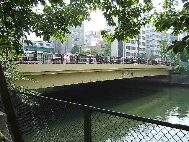
Linggan Bridge: photo #1 taken from downstream river
The Kamejima River (Reigan River), over which the Reigan Bridge is located, crosses Eida-dori Street and enters the Sumida River near 1-chome, Kayabacho, Nihonbashi, Chuo-ku, Tokyo today. In other words, the river that enters the south from the Nihonbashi River is renamed the Kamejima River and leads to Tokyo Bay.
In the old days, the west side of Kamejima River was called Kamejima-kawagishi, and the west bank of Kamejima River was marked as Kamejima-cho Kawagishi-dori in the Nihonbashi Minami Pictorial Map in the Edo period (Bunkyu era), and it is marked as Kamejima-kawagishi in the Nihonbashi Ward Map in the 28th year of Meiji.
Now it is marked as Nihonbashi Kayabacho 2-3 chome, Chuo-ku, and Kayabacho is the name of the town from modern Showa 8. It was named Nihonbashi Kayabacho after Nihonbashi in 1947.
After the Great Kanto Earthquake, Minami Kayabacho, Kitajima-cho 1-2 chome, and Kamejima-cho 1-2 chome were merged into Nihonbashi Ward and became part of Chuo Ward in 1947, leading to the current Nihonbashi Kayabacho 1-3 chome.
The east bank of Reigan Bridge (Shinkawa 1-2-chome) prospered as a berthing place for large ships (Sengokubune) in the Edo harbor, and it was a place that took care of “downstream sake” carried by barrel boats in terms of distribution, and it still retains its appearance today as “downstream sake wholesale store in Shinkawa.
Linggan Bridge: photo #2 taken from downstream river
The Nihonbashi Water Gate can be seen beyond the bridge.
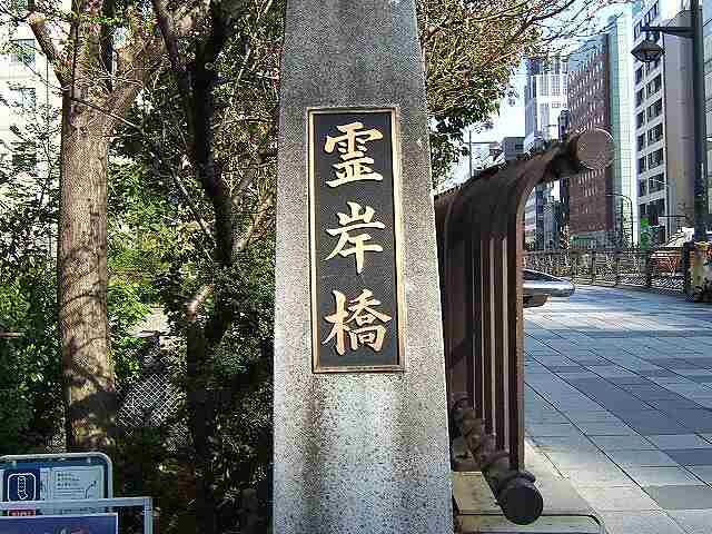
The parent pillar of the Reigan Bridge (Kanji name)
Reigan Bridge is also written as Reigan Bridge.
It has nothing to do with President Reagan of the 40th United States of America (laughs).
The parent pillar of the Reigan Bridge (hiragana name) 
It was 7:50 on a weekday and the place was crowded with people on their way to work.
Shinkamejima Bridge
The second bridge on the Turtle Island River is the New Turtle Island Bridge.
Shin Kamejima Bridge was named Shin Kamejima Bridge because it was built near Kamejima Bridge downstream.
Overview of the new Kamejima Bridge 
This is an overview of the New Kamejima Bridge taken from the upstream Reigan Bridge.
Description of the new Kamejima Bridge 
Shinkameshima Bridge
Shinkameshima Bridge was built for the first time in 1882.
It is recorded that it was a wooden bridge 15 ken (about 27 meters) long and 3 ken (about 5.4 meters) wide in March 1882.
It is recorded that the first wooden bridge was built in March 1882, 15 ken (about 27 meters) long and 3 ken (about 5.4 meters) wide. The bridge was later rebuilt in March 1926 (Taisho 15).
In March 1926 (Taisho 15), the bridge was replaced by a modern steel girder bridge as a reconstruction project after the Great Kanto Earthquake.
The width of the bridge was widened to 15 meters, nearly tripling its original width.
The name “New Kamejima Bridge” was chosen because of its location downstream of the bridge and the fact that it was built in the Genroku era (1688-1704).
The name “Shin Kamejima Bridge” was given to the Kamejima Bridge, which was built in the Genroku era (1688-1704).
The area near the bridge on the Kayabacho side was called Kamejima-cho until the beginning of the Showa era (1926-1989).
It is said that it originates from the fact that there were many people selling bottles in the old days.
It is said that this is the origin of the name of the town. In the Edo period, the houses of the Yoriki under the town magistrate were lined up in rows, and it was also called Kamejima-cho.
Kamejima-cho, where Kamejima faces the ring, is a town with many rice wholesalers who must have made use of water transportation.
The Kamejima-machi area facing the ring of Kamejima was a town with many rice wholesalers that must have taken advantage of water transportation.
On the Shinkawa side of the river, Hishigaki-kaisen and barrel
and barrel boats, and the sake wholesalers
The Shinkawa side of the river was crowded with sake wholesalers who handled sake from the Kamigata region, known as “sake from the upper part of the river”.
It is said that “Koto Shinkawa is known to the whole country with sake wholesalers.
It is said that “Koto Shinkawa is known all over the world with sake wholesalers”.
The river was reborn in the Heisei era as part of the earthquake-proof
The new Kamejima Bridge was reborn as part of the seismic improvement of the Kamejima River.
The new Kamejima Bridge, which has been reborn as part of the seismic revetment of the Kamejima River, is based on the historical relationship between the local area and the
The new Kamejima Bridge was designed in the motif of “Kaisen” based on the historical relationship between the area and the Kamejima River.
The new Kamejima Bridge was designed in the motif of a
The new Kamejima Bridge was designed in the motif of a “Kaisen” (a Japanese traditional Japanese pleasure boat) based on the historical relationship between the area and the Kamejima River. The new Kamejima Bridge was designed with a motif of “Kaisen” (a Japanese traditional Japanese pleasure boat) based on the historical relationship between the area and Kamejima River.
The bridge is designed to convey history and culture to the future generations.
and the design of Ukiyoe style is elaborated in various places.
The design is elaborate with Ukiyoe style design in various places.
September 1997 Chuo Ward
Parapet decoration of the New Kamejima Bridge 
The object in the center of Shin Kamejima Bridge 
Unloading of the cruise ship 
A cruise ship going up the Okawa River 
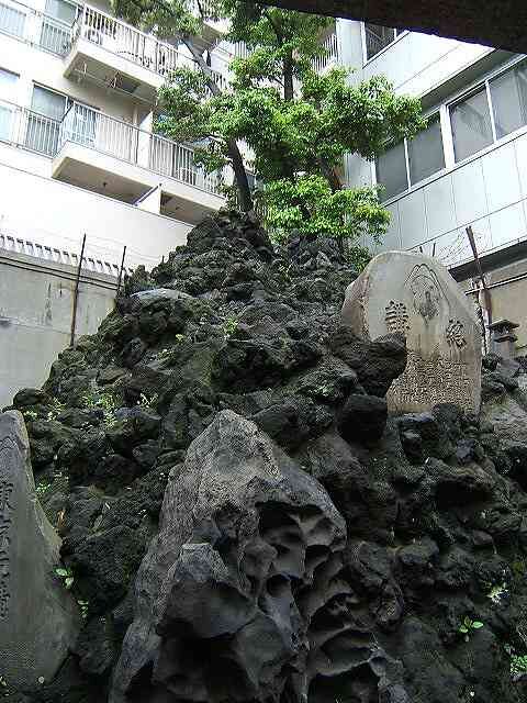
Monument near Shin Kamejima Bridge 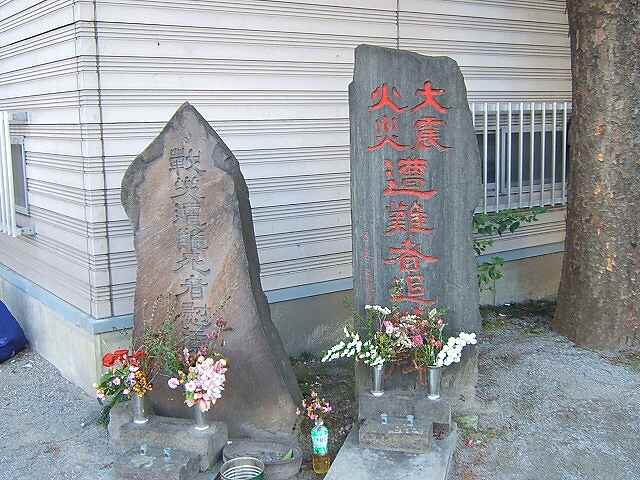
The right is a memorial to the victims of the Great Earthquake. The left is a monument for the war victims.
It seems that the neighbors are making a memorial service, and it is cleaned and there is an offering of flowers no matter what time we pass by.
Kamejima Bridge
The third bridge in Turtle Island River is Turtle Island Bridge.
There is a theory that the name of Kamejima River comes from the name of the town, Kamejima, and that many people who sold bottles lived in the town, and that there was a small island resembling a turtle with a Jizo Bridge built over the moat in the town.
Turtle Island Bridge 
However, since the name of this bridge is Turtle Island Bridge and the image of a new turtle shell is inlaid on the parapet, it may be judged that the theory of “a small island resembling a turtle” is more likely.
It is said that the residences of Horibe Yasube, Toshusai Sharaku and Ino Tadataka were located by the bridge of Kamejima River, and there were also the residences of Kano Sukiyoshi, a painter under the imperial command, and other areas commonly called the Daikan Yashiki and Yaba, as well as Ghost Yokomachi.
Hatchobori 
This Kamejima-bashi bridge is near Hatchobori station on the subway Hibiya line, and it takes less than a minute to get out of the Hatchobori station ticket gates on the Kayabacho station side.
The name Hatchobori comes from a moat (canal) built in the Edo period.
Hacchobori was built in the Kan’ei era (1624-1643) and was called Hacchobori because of its length of eight towns (about 872m).
In the Meiji era (1868-1912), this Hatchobori was also called Sakuragawa or Sakuragawa Canal, but now it is buried and does not exist.
The main pillar of Turtle Island Bridge 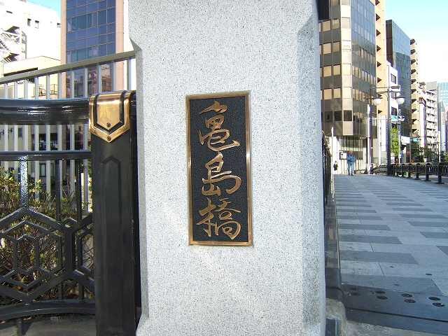
On the left side of this building are the ruins of the residence of Horibe Yasube.
The main pillar of Turtle Island Bridge 2 
There’s romantic lighting on the main pillar!
Parapet of Turtle Island Bridge 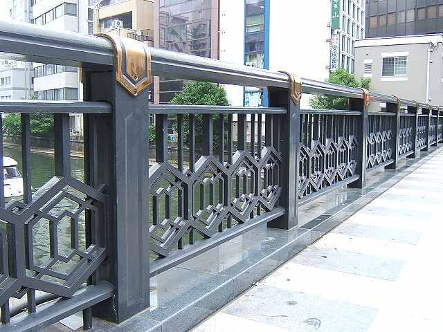
The parapet of the Turtle Island Bridge is designed in the image of a turtle’s shell. As expected, it is the island of turtles (laugh).
In fact, there are turtles living in this river, and I have seen them many times.
Takahashi Bridge
The fourth bridge on the Turtle Island River is Takabashi.
This Takabashi is also known as Kajibashi-dori (Kajibashi Bridge Street).
Takahashi 
Kajibashi-dori stretches from the Imperial Palace and Uchibori-dori Nijubashimae intersection toward Sumida River, crosses this Takabashi, and crosses almost the center of Reigando Island to Eitaibashi Nishi intersection near Eitaibashi.
It is a stylish street in the metropolis that runs all the way from the Imperial Palace to the waterfront.
This is a view of the Takabashi Bridge from the Kamejima Bridge upstream.
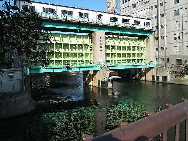
The pink bridge is Taka-bashi, and the light blue steel bridge behind it is Minami-taka-bashi.
The green wall behind the white wagon on the bridge is the Kamejima River sluice gate No.1 and the right side of it is the Kamejima River sluice gate No.2.
The buildings in that direction are on the other side of the Sumida River.
There is a ladder at the left end of the Takahashi. I imagine this is for the landing place in front. Is the ship facing here a surveillance ship? I am sorry if it is not.
The surface of the river is calm and you can feel the peace of the nation (laugh).
This Takahashi, as well as Minami Takahashi, is lit up and beautiful at night. It may be the best date course (^^)
I want to cherish this kind of scenery, peace of mind, and peace.
Takahashi’s Parent Pillar 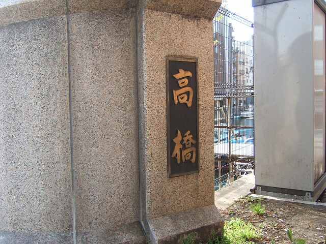
It’s a massive-looking Oyabashira.
Please pronounce it muddled “Takabashi” though reading “Takabashi” is also OK.
The thing seen beyond the net is the landing place which I mentioned above.
According to “Etei Ki” written by Ota Doukan in 1457, Takahashi was originally built near the Otemon Gate in the East Gardens of the Imperial Palace, and was moved to the Kamejima River and built in the early to mid Edo period.
I sometimes hear that Takahashi is derived from a high bridge, and it may have been so in the early days when it was made, but there is no such thing now.
Minami Takahashi Bridge
Bridge No. 5 on the Turtle Island River is the Minamitakabashi.
The origin of Minamitakabashi is Minamitakabashi because it is in the south of Takabashi, and it is a simple naming (^^;
Minami Takahashi 
This Minami-takabashi bridge was built in 1904 and is said to be made of recycled materials from the old Ryogoku Bridge, which was damaged in the Great Kanto Earthquake of 1923.
Parent Pillar of the South High Bridge 
Origin of the South Takahashi Bridge 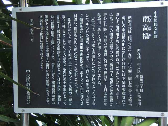
Chuo Cultural Properties
Minami Takahashi Bridge
Location: Shinkawa 2-chome and Minato 1-chome, Chuo-ku (Kamejima River)
The bridge was built in 1931 and completed in March 1931.
There was no wooden bridge built in the Edo period in the present Minami-takabashi area, and the bridge was completed in March 1931.
There was only a bridge upstream of Kamejima Bridge. In the 12th year of the Taisho Era (1923)
(1923), after the Great Kanto Earthquake, when the streets were
a new bridge was built over the Kamejima River between Honminatomachi and Echizenbori 1-chome on the opposite bank.
The city of Tokyo decided to build a new bridge over the Kamejima River between the then Honminatomachi and Echizenbori 1-chome on the opposite bank.
The city of Tokyo had to rebuild many bridges, and the budget became
The city of Tokyo had to rebuild many bridges, and the budget became scarce. Therefore, it was rebuilt in 1904 (Meiji 37), and the Sumida River
The central section of the triple truss of the Ryogoku Bridge on the Sumida River, which was damaged in the
The bridge was reinforced and narrowed in width and built as the Minami-taka-bashi (south bridge).
It is rare that a part of the truss bridge built in 1897 remains in Tokyo.
It is valuable as a civil engineering heritage of the modern age in the meaning that it comes to remain at present.
It is valuable. The only other steel truss bridge remaining in Tokyo is the Hachiman Bridge (former Danjo Bridge), which was moved to Koto Ward.
Yawata Bridge (former Danjo Bridge), which was moved to Koto Ward, is the second oldest steel truss bridge remaining in Tokyo, and the first steel truss bridge that can be used for vehicular traffic.
It is the sixth oldest steel truss bridge in Japan that can be used for vehicular traffic.
It is registered as a Tangible Cultural Property of Chuo City.
March 2002, Chuo City Board of Education
Turtle Island River sluice gate seen from Turtle Island River 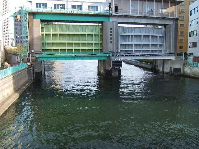
Kamejima River sluice gate seen from Sumida River 
Illustration of Kamejima River sluice gate